Mountain biking is a fun way to exercise outside in nature. Trails in the Brazeau and Beyond vary from wide paths of the Pembina Nordic Ski Trails and the Pembina Rotary Community Trails South, to single track at the Pembina Nordic Centre, and the hilltop/hillside trails in Eagle Point Provincial Park.
Mountain biking in the region meets all rider types and skill levels.
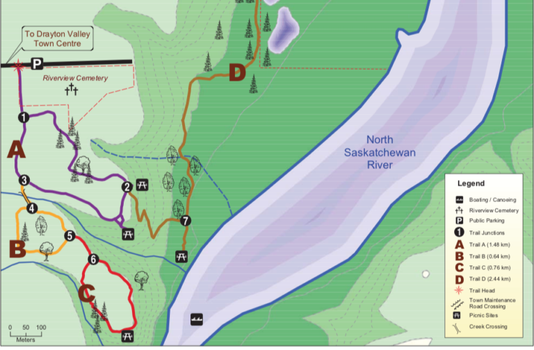
Beginner Route Ideas: Pembina Rotary Community Trails South (Cemetery Trails)
For beginner mountain bike riders, going to the well trodden wide paths of the Pembina Rotary Community Trails South (located next to River View Cemetery) is a good place to start. The trails are often used as walking paths. They are mostly flat with a few ravines and switchbacks thrown in for variety. There are also bogs, and slippery mud to keep you on your toes.
These circular paths connect to form a circuit of figure eights. While the paths can be ridden by any beginner level mountain biker, the transitions between the paths can make them a little more demanding.
Getting to the trails
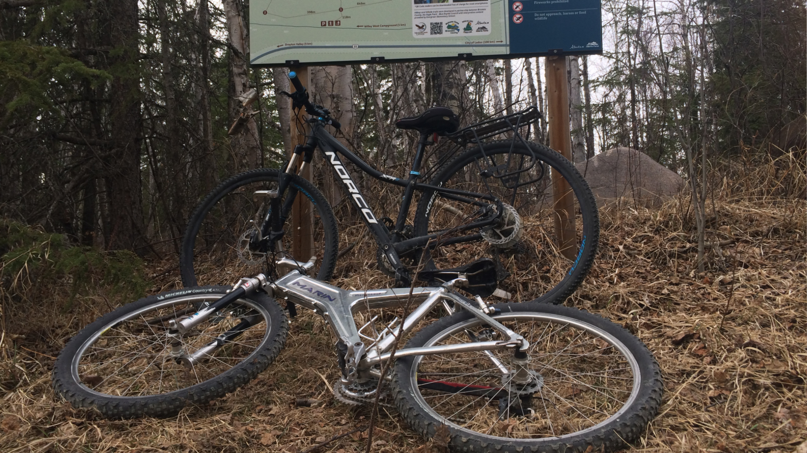
The trails are a 4-minute drive from downtown Drayton Valley. They are located next to River View Cemetery. There is off street parking at the trailhead as well as a kiosk with the complete trail map.
Route starts at “A” Loop:
This 1.48 km loop is an easy introduction to mountain biking. With no roots, or rocks, navigation is pretty straight forward, however there are a few seasonal bogs, and after a rainfall there are some muddy spots to navigate.
While on the loop you will easily see the well trodden path that local walkers make. This loop can be done on its own or as part of a quick warm up or cool down ride.
Transition to “B” Loop
“B” Loop is another great beginner ride with some ups and downs. Again no rocks or roots, just grasses, and leaves that can be slippery. The trickiest part of the ride will be the steep ravine transition between “A” Loop and “B” Loop. This ravine is steep, and muddy. The mud tends to have a cake consistency that will stick to everything so the best time to go is weather and season dependent.
Transition to “D” Loop
Once you get down the hairpin switch backs from “A” Loop to “D” Loop, then the “D” Loop is a cake walk. With little in the way of elevation transitions you are in for a relaxed scenic ride along the banks of the North Saskatchewan River. “D” Loop is not really a loop bu tan out and back route. The road at the end is private property and municipally managed.
Transition to “C” Loop from “B” Loop
Nothing out of the ordinary for this transition. One notable mention of the “C” Loop is the halfway point. Halfway around the loop you will come to a panoramic viewpoint of the North Saskatchewan River, Willey West Campground and the river bridge. If you packed a backpack this would be a great place to cop a squat and have some lunch.
What to bring
- Bring a camera (phone) for those amazing photo opportunities
- Bring some bug spray in the summer months
- Wear footwear that can get muddy.
Points of Interest:
- Panoramic viewpoint of the North Saskatchewan River Valley on “C” Loop
- Fiddlehead Fern forest “D” Loop
Intermediate Ideas: Pembina Nordic Ski Centre (Trails)
Another mountain bike destination is the Pembina Nordic Ski Centre. This center is managed and maintained by volunteers. There are public access options but if you are using the trails purchasing a membership or donating for day use is recommended.
During the summer the trails at the Pembina Nordic Ski Center are used for all sorts of outdoor activity including disc golf, walking and mountain biking.The ski centre has both wide trails and a single track option that can be explored.
Because there are a number of activities going on at any given time be mindful of the take off points for each of the trail rides.

Getting there:
The Pembina Nordic Ski Trails is a 12 minute drive from Drayton Valley. There is on and off road parking at the various entrance points. Tail maps are posted at entrances, and along the trails.
Pembina Nordic Ski Members will be able to access the parking lot at the chalet. Non-memebers will not have gate access and so may have to park on the road and go through a small trail on the left hand side of the gate, and ride to the chalet.
North Loop 3.6 km
Technical features beginner/Physically intermediate
The North Loop can be accessed on its own or a part of the Evergreen Loop. The North Loop is situated on a gradual hillside and so it keeps relatively dry during the summer months, with a couple of small mud traps on the west side of the loop.
The North Loop has minimal roots and rocks and makes for a pretty straightforward ride. However there are a number of hills and so this ride will be most enjoyed if you have a bit of a fitness base.
The whole circuit can be done in about 35-40 minutes and is a great conditioning route. You can tackle this circuit either clockwise or counter clockwise. Going counter clockwise (bearing left of the trailhead) you will start climbing immediately but then you are rewarded with some downhill segments. This is a fun little route to try out and is kid friendly.
Accessing the trail:
- Access this trail from the bottom of TWP494. Drive to the end of TWP 494 the trail is on the north side of the road.
- Take off from the Pembina Nordic Chalet, head north on the Evergreen Loop. Do not go South or you will find yourself on the disc golf course. Follow down an aggressive S – bend hill. At the bottom continue to bare left and you will be taken around to the North Loop.
Distance: 3.6 km
Approximate time: 35-40 minutes (moderate fitness level)
What to bring:
- Camera (phone) to capture the moments
- Bug spray in the summer months
- Optional clip in shoes
Points of Interest:
In July there are an abundance of wild strawberries on the east side of the loop.
Evergreen Loop 3.3 km
Technical features beginner/Physically intermediate
The Evergreen Trail noted on the nordic ski map is a multi use trail that includes a disc golf course on the top section of this loop. If you are riding the Evergreen Loop you can go clockwise or counter clockwise the only difference is how you want to climb back up either directly (clockwise route) or with a semi-switch back (counter clockwise). This is a trail that can be easily navigated by a beginner with good endurance.
Clockwise route: On this route you leave heading north from the Pembina Nordic Ski Chalet and complete the loop bearing left. Your adventure starts with some rolling hills, heading on a downward slope that leads in to a downhill “S” bend. At the bottom of the hill there is a wet section you will have to pedal through.
The trail flattens off at the bottom. Here you will come to an interaction fo trial where you can go straight to the North Loop, right to a trail cut across (not well groomed) or follow the main Evergreen Trail. You can continue to follow the main trail around a steep up hill slope bearing left to the Nordic Ski Cabin or you can bear right take a cut across that will get you back to where you started at the Pembina Nordic Ski Chalet.
Counter clockwise route: This route starts at the front door fo the Nordic Ski Cabin. On this route you can head on the main trail, watching out for disc golfers, or bear right and you will see the opening to a single track trail (under development).
The single track trail has some roots, and rocks. Beautiful views of the North Saskatchewan River. It also comes up to a picnic area and a view point.
Accessing the trail:
- North of the Pembina Nordic Ski Chalet (clockwise)
- Head past the nordic ski cabin and keep bearing right down the hill. (counter clockwise)
- Trail access point from end of TWP 494, bottom of the hill.
Route extension: The North Loop accessed via the Evergreen Loop.
Distance: 3.3 km
Approximate time: 20-25 minutes
What to bring:
- Camera (phone) to capture the moments
- Bug spray in the summer months
- Optional clip in shoes for uphill portions
Points of Interest:
- Access to the single track trail.
- Views of the North Saskatchewan River

Single Track Routes
Single track riding along the North Saskatchewan River Valley is a fun way to get introduced to the sport, or conditioning for a season of mountain biking.
The single track has rollers, berms, and switch backs. It makes for a great training ground and is family friendly.
Pembina Nordic Ski Trails single track system:
Getting there and trail maps:
The Pembina Nordic single track trails are located at the Pembina Nordic Ski Centre on TWP 494. This is the same location as found in our intermediate trail ideas, noted above. The trail map is the same, the single track trails are noted as walking trails on the trail map.
Evergreen Loop/Ridge Loop: Pembina Nordic Ski Trails
The single track on the Evergreen Loop and the Ridge Trail are still under development but some can be found on the Pembina Nordic Trail Map noted “walking trails”. The track that is developed is a ton of fun and has exceptional views of the river valley.
The track weaves on and out of the established nordic ski trail so it is a great place for mountain bikers new to the sport to choose their own challenge.
Accessing the track:
Ridge Loop: Begin at the Nordic Ski Cabin staging area to far right of the fire pit along the treen line you will find a trail opening. This is an entrance point that takes your westward along the North Saskatchewan River Valley.
This is a multi use trail that has hills, tree roots, and boardwalks, and some walkers. There are some beautiful view points to pause and catch your breath.
This trail runs along the Ridge Loop. Popping out on the nordic ski trail, is an easy ride heading back to the nordic ski cabin will complete the loop.
Evergreen Loop: Begin at the Nordic Ski Cabin and bear right. The trailhead is easily found along the tree line.This is a multi-use trail, and does run along side the DV Top Gun Disc Golf Course. This trail is a moderate decent, with tree roots, rocks and grasses. The trail intersects with the Evergreen Loop at several points. It is a steady decline until you reach the bottom of the hill, then you will cycle along the bottom flat heading towards the North Loop.
To complete the ride you can either:
- Head right at the trail junctions and continue your ride along the North Loop.
- Head straight at the junction and pop out on TWP 494 and ride back up to the chalet on the gravel road
- Head left at the junction and ride up the Evergeen Loop. If you go this way the bottom portion before and “S” bend uphill, is a little boggy so maintain speed. The ride up is a lung buster. The top this route intersects with the DV Disc Golf Course. Distance: 3.3 km, 25 minutes for an intermediate skill level.
Additional tracks:
West Ridge Winder heading west from the old chalet.
West loop (under construction )
Points of interest:
- Panoramic views of the river valley
- DV Disc Golf Course
Eagle Point Provincial Park Hillside Trail system: Non-Mountain intermediate
The Hillside Trail system is one of two circular trail circuits located in the Eagle Point Provincial Park, that make up the Hilltop and the Hillside trails. This trail is nestled among a forest of birch, poplars and spruce trees. In the winter this trail is used for snowshoeing but in the summer this multi-use trail is visited by mountain bikers and hikers.
These are rough, narrow trails, with roots, rocks and the occasional fallen tree.
Getting there:
Leaving Drayton Valley head east on Hwy 22. Over the North Saskatchewan River bridge and continue driving until you reach signage for RR 70, and Eagle Point Provincial Park. Turn left at the sign and follow the road around take a right on to RR71 and then you first left onto a lease road. The road can have some muddy spots. Drive, past the signed trailhead to the end of the road to the decommissioned pump jack and park. This is your jump off spot.
If you are looking to only do half the circuit and have a shuttle, then your shuttle vehicle will need to carry on down RR 71 to the bottom of the gravel hill, turn left on to the locked lease road at the bottom. This is where you park.
Access points:
There are four access points to this trail system.
- Trailhead mid-way down the unmarked lease road there is trail map signage. Small space of off road parking.
- Further down the lease, there is an access point at at the end (decommissioned pump-jack), large boulders noting the trailhead.
- From the river side, off a connector piece of land, this can be accessed from the lease road at the bottom of the circuit or from the Hilltop Trail
- The lease road at the bottom of the circuit, this also can be used as a trail exit point.
What to expect:
This trail a narrow well packed single track. There is root exposure, leaves, small trees and grasses. With moisture or a fresh rain, parts of the trail can get slippery.
There is a number of up and down sections. With quick transitions between up and downhill. The shuttle routes we outline are short and can easily be lengthened if you want to extend your ride.
From the pump jack entrance: Top to bottom routes (vehicle shuttle system):
- Turning right trail “7-8-10” sequence: on this trail you traverse across the top with some downhill and uphill sections before heading down to the bottom of the circuit.
- Going straight heading on trail “7-9” sequence: This sequence gets into an immediate downhill, with the traverse happening at the bottom of the circuit.
- River route trail “7-6” sequence: A sequence of downhill, with popping out on a land flat along the North Saskatchewan River. Out of the trail head right following the river to the bottom lease road.
Points of Interest:
- North Saskatchewan River
- Bow Benders Archery Range (Members Only)
- Hilltop Trails
- Willey West Interpretative Trails
Eagle Point Provincial Park Hilltop Trail system: Non-Mountain intermediate
The Hilltop Trail system is one of two circular trail circuits located in the Eagle Point Provincial Park that make up the Hill top and Hillside trail systems. This trail is accessed on the way to Willey West Campground. This multi-use trials are use for mountain biking and hiking.
Getting there:
Leaving Drayton Valley head east on Hwy 22. Over the North Saskatchewan River Bridge and continue driving until you reach signage for RR70 and Eagle Point Provincial Park. Turn left and follow the signage to Willey West Campground.
Just inside the campground gate your will find the trailhead on the right.
Access points:
- Trailhead access off the Willey West Campground road
What to expect:
This circuit is a packed trail with leaves and some root exposure. It is a great trail with some beginner options, and intermediate challenges.
Heading left off of “1” route you will find some uphill and downhill. Heading right from “1-4-1” circuit is flatter and a great starting place for young mountain bikers.
Points of Interest:
- North Saskatchewan River
- Willey West Interpretative Trails
- Hillside Trails
- Hidden Trail